Attention trail users: The written directions, guidebooks, maps, and GPS files provided by the Mojave Desert Heritage and Cultural Association (MDHCA) should not be relied upon as the sole basis for navigation. The road data may not reflect current conditions resulting from road damage, construction, closures, private property, or boundary changes. The user assumes full responsibility and all risks associated with using the information provided and uses these directions at his/her discretion.
As a Native American Trade Route
The Mojave Road we are privileged to use today had its origin as a trade route from the Mojave villages along the Colorado River to the Pacific Coast. There were some seasonal variations in the network of pathways. For the most part, the route we follow today is recognized as having had the most reliable water sources for those crossing the desert. The Mojave carried goods such as seeds, corn, beans, and pottery to trade with the coastal Indians in exchange for shells, beads, and feathers. It has been suggested that the Mojave may have conducted these trips as much for adventure as for trading.
Paving the Way for Today
The first non-Indian recorded to have been guided across the desert by Mojave Indians was Fr. Francisco Garcés in 1776. It was 75 years later that Jedediah Smith was also led west from the Colorado River to the Mission at San Gabriel.
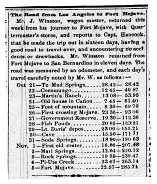
Continued westward expansion led to government surveys in Arizona Territory and California. Attempts to locate a railroad route along the 35th parallel to the Pacific brought surveys in 1853 and ’54. In 1857 Edward F. Beale was charged with locating a wagon road westward from Fort Smith, Arkansas. The first emigrants to try Beale’s route encountered hostile Mojave and returned east. As a consequence of this event, Fort Mojave was established and the numerous supply trains that crossed the desert from Los Angeles firmly established the Mojave Road.
As a Backcountry Recreation Trail
In his book Reopening the Mojave Road – A Personal Narrative, Dennis Casebier begins the narrative “It was during 1962 that I first became acquainted with the Mojave Road – or Old Government Road, as it was almost universally called at that time.” With his passion for the desert and for historical research it was fortuitous that he was working as a physicist for the Navy and in that capacity, he spent considerable time in Washington D.C. This allowed him the opportunity to spend evenings and weekends at the National Archives and Library of Congress gathering primary source material related to the Mojave Road. Ten years of historical research, encouraged by such notable western historians as Dr. Benjamin Sacks, Bert Fireman, E. I. “Eddie” Edwards, and others, resulted in a manuscript but more importantly it was only through on the ground discoveries that he was able to locate as much of the original Mojave Road as possible. It was then time to decide how to deal with the subject, how to introduce others to this wonderful historic artifact that is one-hundred and thirty miles long and eight feet wide. In those miles the Mojave Road passes through the heart of the Eastern Mojave Desert, an area considered by many to be the most beautiful and attractive of all California desert regions.
Early discussions with the BLM, who at the time managed the area as the East Mojave Scenic Area, focused on just how, and if, to develop the trail for public use - hiking, equestrian, or perhaps four-wheel-drive vehicles. In March 1980, Dennis led an Associated Blazers of California 4x4 group across the Mojave Road as its notoriety grew. It was after that experience that Dennis noted “I do believe that the great bulk of use [of the Mojave Road] will come from four-wheelers; and I am convinced that for all of them, it will be an enriching and rewarding experience, especially if they have a guide that helps them understand the desert.”
To accomplish the lofty goals of establishing and marking a 130-mile trans desert vehicle route, a volunteer group was formed during a meeting on May 10, 1981. The Friends of the Mojave Road in conjunction with the Bureau of Land Management worked to bring the recreational use of the “Road” concept to reality. Actual physical work began in the fall of 1981. Numerous work parties continued their effort establishing a sparingly marked route from the Colorado River to Camp Cady. Draft copies of a guide were reviewed on the ground and by the fall of 1983 The Guide to the Mojave Road was at the print shop. Through several reprintings, some necessitated by the Park Service removing some landmarks that had been used for navigation points of the route, and the desire to add GPS waypoints, the Mojave Road Guide has been updated. It provides mile by mile directions as well as key information and a look at the history and natural resources of the desert.
Mojave Road Bypasses and Closures
From time-to-time portions of the Mojave Road are closed by the Mojave National Preserve. These are usually temporary and most commonly due to flood or water runoff damage. The Mojave Road where it crosses over the Piute Range and Soda Lake are the two places within the Preserve that have been subject to these closures to prevent resource damage. A third place, the water crossings in Afton Canyon, may be particularly deep at times and thus are intimidating for some drivers so an alternative route is also provided.
Download Tracks
KML Files -
The KML tracks for Mojave Road bypasses are available here. The KML format is compatible with most GPS units and may be used with Google Earth. Convenient separate files make it easy to load the segment you want to update. - Last Update 12/20/23
Google Earth maps: Afton Canyon Bypass Piute Hill Bypass Soda Lake Bypass
KML files (File - Download): Afton Canyon Bypass Piute Hill Bypass Soda Lake Bypass
Explore the Collection
Order Your Guidebook to gain in-depth knowledge about the history as you drive along.