Attention trail users: The written directions, guidebooks, maps, and GPS files provided by the Mojave Desert Heritage and Cultural Association (MDHCA) should not be relied upon as the sole basis for navigation. The road data may not reflect current conditions resulting from road damage, construction, closures, private property, or boundary changes. The user assumes full responsibility and all risks associated with using the information provided and uses these directions at his/her discretion.
Introduction to the Bradshaw Trail
The Bradshaw Trail is a historic overland stage route and ancient Indian trail in the Colorado Desert of Southern California. In 1862 William Bradshaw and James Grant, separately first, then together, established the first road from San Bernardino to the recently discovered placer gold diggings east of the Colorado River eighty or so miles north of Arizona City (Yuma), in the soon to be created Arizona Territory. It became an overland stage route, heavily traveled from 1862 to 1877, transporting miners and other passengers to the gold fields and beyond.
The Gold Road to La Paz – An Interpretive Guide to the Bradshaw Trail (Delmer G. Ross, Tales of the Mojave Road Publishing Company, 1992) will take the reader, whether in an easy chair at home, or behind the wheel of a 4x4, through the history, flora, and fauna of an eighty-plus-mile trip across the desert.
Remember that the route in this guidebook was published working with the BLM in 1992. There have been many changes to the area this route passes through since that time. The “Bradshaw Trail Access Supplement” below addresses two of those changes. In the “How to Use this Book” section of the original publication is this advice and is still applicable: Neither the author nor the publisher – nor anyone else, for that matter – can guarantee the continued drivability of any road or portion of road described in this volume. It is your responsibility to respect signage, private property, and wilderness areas.
Bradshaw Trail Access Supplement
by Tim Augustine
The Bradshaw Trail is described in the guidebook, Gold Road to La Paz, An Interpretive Guide to the Bradshaw Trail by Delmer G. Ross. Published in 1992, the guide has become outdated with legal changes to the desert in the intervening years, such as the Desert Protection Act and others, that have created wilderness areas or areas closed to the public where there were none before.
This supplement will address those changes and offer a legal alternative to the beginning of the route as described in Gold Road to La Paz, which is no longer a compliant route. The original route, as described in the book, crossed Bureau of Land Management (BLM) land and private land that is no longer accessible. It led the reader onto the Coachella Canal access road on the south side of the canal. This road is now closed to access by the public, as the Coachella Valley Water District had installed gates and fencing along a portion of the southern canal road. Any attempt to bypass the gate or fencing could result in a citation by the Sheriff.
The alternative route, provided by the BLM, crosses the canal to the northside and uses the old canal access road until the Bradshaw Trail leaves the canal altogether, heading east.
As you will find once you arrive in the area, the Coachella Canal is actually comprised of two canals. The old canal and the new canal. The new canal is concrete lined and contains water. The old canal lies just to the north of the new canal, is just a deep sandy ditch and contains no water. There are three roads adjacent to these canals. One road between the two canals, and one road on the outer edge of each canal. The two roads beside the new canal are off limits, the road on the north side of the old canal is legal and accessible. This is the road to use. As you drive this road heading east, you will have both canals visible on your right. Directions below.
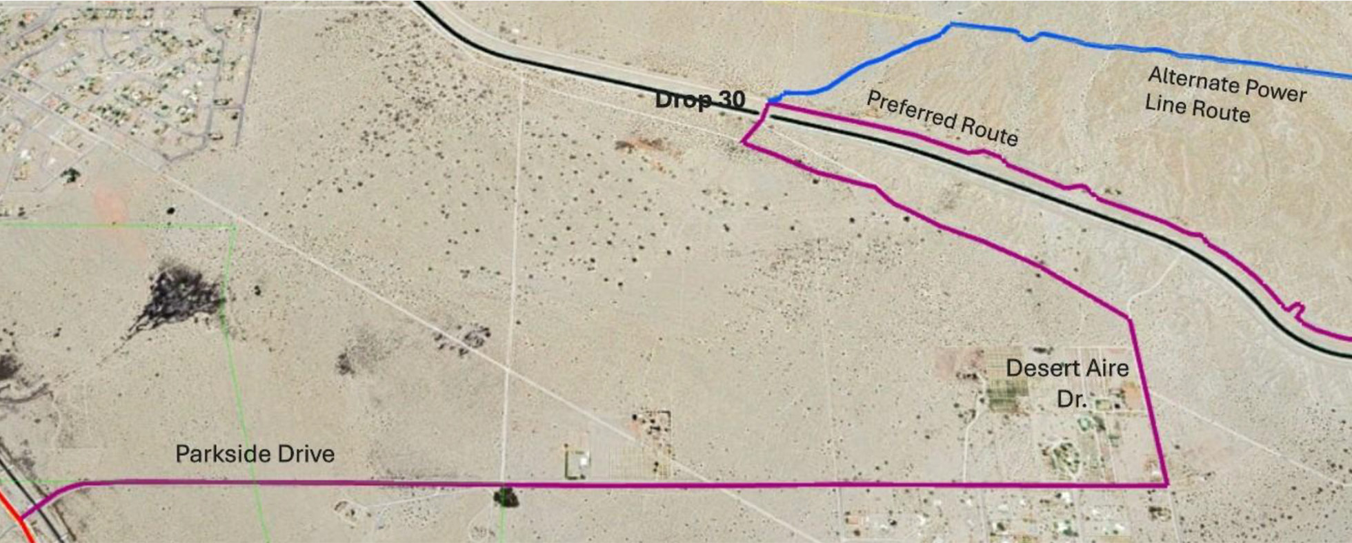
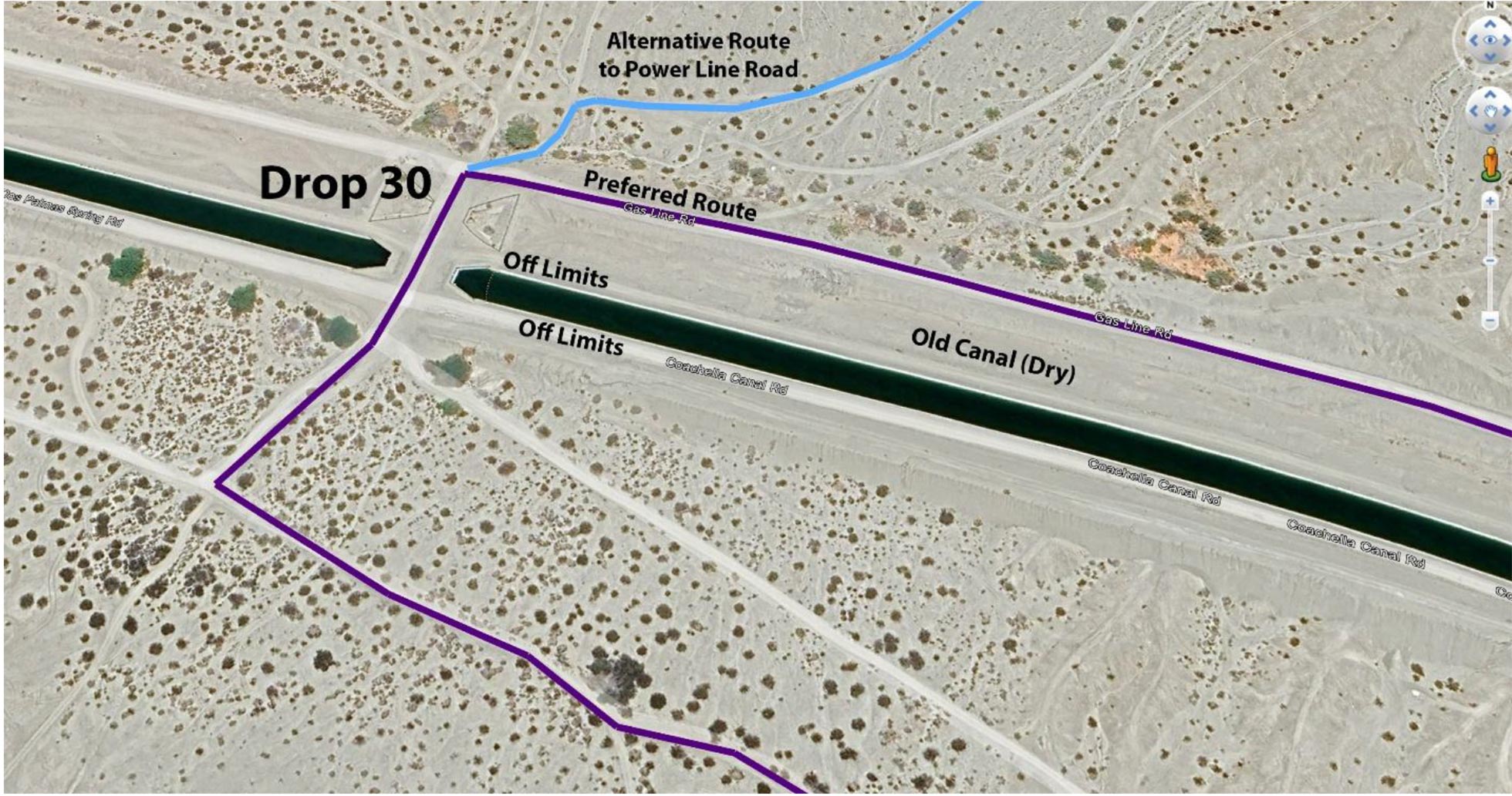
Above: Detail Map at Drop 30
Beginning on page 57 of the guide, the reader is directed to turn east off Highway 111 at Parkside Drive (33.50996, -115.91703). This is still valid. Follow Parkside Drive until it ends at Desert Aire Dr. (33.51074, -115.88701). Turn left (north) on unpaved Desert Aire Dr. Travel about 0.3 miles to a fork in the road (33.51516, -115.88708).
Take the left fork and travel about 0.8 miles across state land to a junction at Drop (or siphon) 30 (33.52067, -115.89777). Drops are low places where the canal goes underground and allows flow in natural washes to cross the canal without filling it with sand and dirt. The drops are numbered increasing from east to west (flow direction). There are several signs indicating the drop number on the fence surrounding the canal.
Turn right and pass through Drop 30, to the north side of both canals. Immediately after passing through the drop on the north side, the old canal access road climbs up from the drop
(33.52193, -115.89683). Turn right and take this access road “preferred route” shown above, approximately 9 miles until you reach wide drop 24.
You will see lots of “No Trespassing” signs. These refer to the canal and the areas off the access road in several places. The road will briefly leave the canal at washes, before returning to the canal. Stay in the well-traveled tracks.
Alternatively, after crossing Drop 30, you can continue a short way and access the power-line road to the north. This road eventually intersects the canal access road midway to Drop 24.
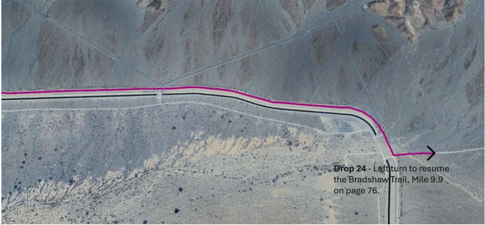
Descend into the wash at Drop 24, passing nearly to the other side of the wide drop. You will see a BLM kiosk with information on the Bradshaw Trail (33.50592, -115.76597). Turn left here and pick up the directions in the guidebook on pages 76/77, with the “Salt Creek Route.”
I recommend reading the pages between pages 57 and 77, as they contain information about the land you are passing through, even if the directions are no longer accurate.
Note: The side trip called the “Orocopia Mountains Loop” mentioned on page 82, and described starting on page 235 is no longer a compliant loop. The beginning and end are accessible, but the middle portion is now inside wilderness and is closed to motorized travel. There are fences at the wilderness boundary, but they may not be well-marked. Use caution that you don’t inadvertently drive into the wilderness area if you take these side trips.
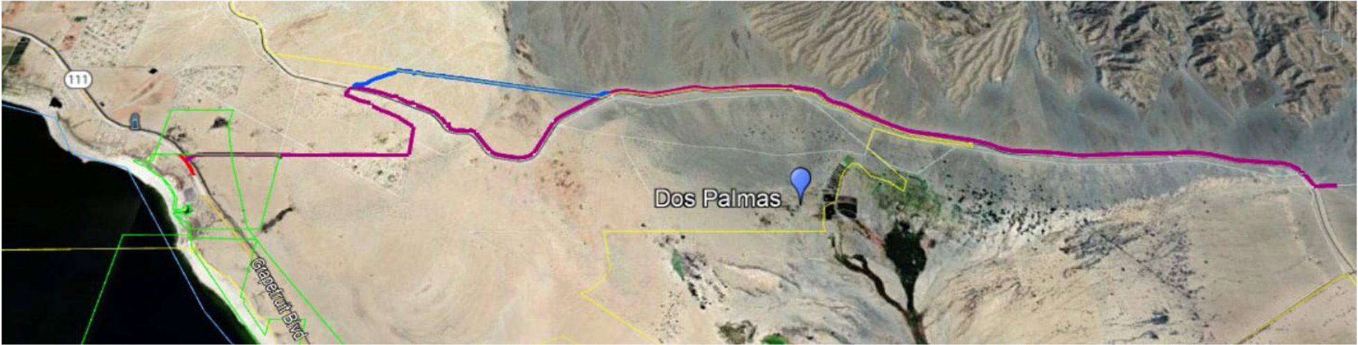
Below: Overview to the start of the Bradshaw Trail
Download Tracks
KML Files -
The KML tracks for Bradshaw Trail bypasses are available here. The KML format is compatible with most GPS units and may be used with Google Earth. Convenient separate files make it easy to load the segment you want to update.
Google Earth maps: Bradshaw Trail
KML files (File - Download): Bradshaw Trail